Archaeology
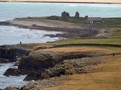
 There are clear lines of sight from Sumburgh up the coast to Jarlshof
Sumburgh Head has a rich archaeological history which can be traced back for thousands of years.
The strategic importance of Sumburgh has been recognised from the Iron Age when it was the site of a promontory fort, right through to its use during World War II. The height of Sumburgh Head allows for good lines of sight up along the coast - to the Ness of Burgi and Jarlshof on the west coast, and there is a clear line of sight to Mousa, on the east coast which could have been visible if, for example, a beacon was lit there.
The word Sumburgh means ‘south fortification’ from sunn, meaning south and burgh, meaning fortified place - this is the origin of the word broch. Sumburgh Head has played a role in protecting Shetland at several points in the story of the islands beginning more than 2,000 years ago when people first began to defend themselves.
Sumburgh was the first landfall on the Shetland mainland throughout prehistory as visitors would have come from the south. On a clear day they could see land all the way, hopping from Scotland to Orkney to Fair Isle to the Shetland Mainland. As a result, the southern end of Shetland was heavily populated and perhaps this is why it was so heavily defended.
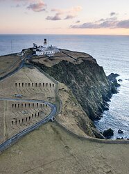
 Banks of the Iron Age Fort are indicated here (image taken by Frank Bradford)
The 'Ancient Fort of Swenburgh' was recorded in 1654 and the Iron Age buildings were described in 1774 (by George Low) as being "a ditch and a strong wall". Today, all that survives are the banks - pictured here and indicated by the triangle shapes. Low described the buildings as including "a large house which probably served as a guard room" alongside the wall. He also described numerous small buildings as "looking like those in Blue Mull in Unst". Archaeologists therefore think that the layout of the fort would have been very similar to that at the Ness of Burgi across the water.
 The layout of the fort at Sumburgh would have been very similar to that at the Ness of Burgi across the water. (image by Frank Bradford)
To find out more about the Iron Age, visitors should go to Old Scatness Broch and Iron Age Village, one mile north, and also Shetland Museum and Archives in Lerwick.

